
Файл:Okavango River Basin map.png

Оригинален файл (3052 × 3160 пиксела, големина на файла: 8,63 МБ, MIME-тип: image/png)
| Този файл е от Общомедия и може да се използва от други проекти.
Следва информация за файла, достъпна през оригиналната му описателна страница. |
Резюме
![]() Do not add Template:Convert to SVG, because the source is a pdf file with a pixel image, not a vector image.
Do not add Template:Convert to SVG, because the source is a pdf file with a pixel image, not a vector image.
| Описание |
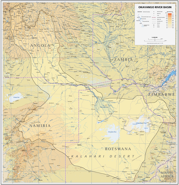
Afrikaans: Kaart van die opvangsgebied en waterskeiding (stippellyn) van die Kavangorivier in Angola, Namibië en Botswana
English: Map of the Okavango River Basin, with catchment area inside the dotted line (Angola, Namibia, Botswana) |
| Дата | |
| Източник | https://digitallibrary.un.org/record/423191?ln=en |
| Автор | United Nations |
| Права (Повторно използване на файла) |
UN map as PD |
| други версии |
 |
| This image is a map derived from a United Nations map.
Unless stated otherwise, UN maps are to be considered in the public domain. This applies worldwide. UN maps are, in principle, open source material and you can use them in your work or for making your own map. UN requests however that you delete the UN name, logo and reference number upon any modification to the map. Content of your map will be your responsibility. You can state in your publication, if you wish, something like: based on UN map … (map name, map number, revision number and date). See: Geospatial Information Section. And: Geospatial, location data for a better world. |
 |
История на файла
Избирането на дата/час ще покаже как е изглеждал файлът към онзи момент.
| Дата/Час | Миникартинка | Размер | Потребител | Коментар | |
|---|---|---|---|---|---|
| текуща | 14:22, 6 януари 2019 | | 3052 × 3160 (8,63 МБ) | JMK | adjust midtones |
| 17:09, 16 април 2008 |  | 3052 × 3160 (8,15 МБ) | Foundert~commonswiki | {{Information |Description=map of the Okavango River Basin (Angola, Namibia, Botswana) |Source=http://www.un.org/Depts/Cartographic/english/htmain.htm |Date=16. April 2008 |Author=United Nations |Permission=UN map as PD |other_versions= }} {{UN map}} [[ |
Използване на файла
Следната страница използва следния файл:
Глобално използване на файл
Този файл се използва от следните други уикита:
- Употреба в af.wikipedia.org
- Употреба в ar.wikipedia.org
- Употреба в ast.wikipedia.org
- Употреба в avk.wikipedia.org
- Употреба в azb.wikipedia.org
- Употреба в ca.wikipedia.org
- Употреба в cs.wikipedia.org
- Употреба в da.wikipedia.org
- Употреба в de.wikipedia.org
- Употреба в el.wikipedia.org
- Употреба в en.wikipedia.org
- Употреба в es.wikipedia.org
- Употреба в fi.wikipedia.org
- Употреба в frr.wikipedia.org
- Употреба в fr.wikipedia.org
- Употреба в gl.wikipedia.org
- Употреба в he.wikipedia.org
- Употреба в hr.wikipedia.org
- Употреба в hu.wikipedia.org
- Употреба в id.wikipedia.org
- Употреба в it.wikipedia.org
- Употреба в ja.wikipedia.org
- Употреба в ka.wikipedia.org
- Употреба в ko.wikipedia.org
- Употреба в lv.wikipedia.org
- Употреба в mk.wikipedia.org
- Употреба в ml.wikipedia.org
- Употреба в nl.wikipedia.org
- Употреба в oc.wikipedia.org
- Употреба в pl.wikipedia.org
- Употреба в pt.wikipedia.org
- Употреба в ro.wikipedia.org
- Употреба в sh.wikipedia.org
- Употреба в sk.wikipedia.org
- Употреба в sr.wikipedia.org
- Употреба в sw.wikipedia.org
- Употреба в ta.wikipedia.org
- Употреба в th.wikipedia.org
Преглед на глобалната употреба на файла.