
Файл:Sámova říše.png

Оригинален файл (852 × 850 пиксела, големина на файла: 184 КБ, MIME-тип: image/png)
| Този файл е от Общомедия и може да се използва от други проекти.
Следва информация за файла, достъпна през оригиналната му описателна страница. |

|
Това изображение (или всички изображения в тази страница/категория) би трябвало да бъдат пресъздадени с използване на векторна графика във формат SVG. Това има няколко предимства; вижте Commons:Media for cleanup за повече информация. Ако разполагате с това избражение в SVG формат, моля качете го. След това заместете този шаблон с {{Vector version available|име на новия файл.svg}}.
|
| Описание |
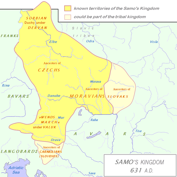
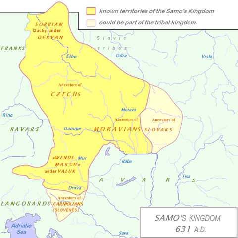
English: Tribal Kingdom of Samo.
Map is based on the maps in:
It is also based on descriptions in:
For eastern and southern extant of tribal kingdom: known territories are shown by the scheme of franco-slavic border and information about the conflicts with Avars is imlemented. The inclusion of Bohemian basin is followed. Contacts with Avars are reached through the territory of Moravians and Eastern Alps. The territories further east and south, which are in proximity of Avars, could be parts of tribal kingdom, too. |
| Дата | (UTC) |
| Източник | |
| Автор |
|
| This is a retouched picture, which means that it has been digitally altered from its original version. Modifications: The map of Danube basin was used to create map of Kingdom of Samo. The original can be viewed here: Tribal Kingdom of Samo-sl version.PNG:
|
| Аз, носителят на авторските права над тази творба, я публикувам като обществено достояние. Това разрешение е в сила за целия свят. В някои държави това може да не е възможно от законодателна гледна точка; затова: Давам на всекиго правото да използва тази творба за всякакви цели, без никакви условия, освен ако такива условия съществуват по закон. |
Дневник на оригиналното качване
This image is a derivative work of the following images:
- File:Waterways_of_SE_Central_Europe.svg licensed with PD-self
- 2010-01-08T20:49:27Z Kmiki87 1415x1059 (292577 Bytes) {{Information |Description={{en|1=Waterways along the central and lower Danube, including the Bohemian and Carpathian Basins, the northern Balkans, parts of Austria, southern Poland and Western Ukraine.}} |Source={{own}} |Aut
История на файла
Избирането на дата/час ще покаже как е изглеждал файлът към онзи момент.
| Дата/Час | Миникартинка | Размер | Потребител | Коментар | |
|---|---|---|---|---|---|
| текуща | 14:27, 3 януари 2013 | | 852 × 850 (184 КБ) | DancingPhilosopher | Better map based on http://commons.wikimedia.org/wiki/File:Tribal_Kingdom_of_Samo-sl_version.PNG |
| 14:13, 28 октомври 2010 |  | 536 × 474 (616 КБ) | Aktron | == {{int:filedesc}} == {{OpenStreetMap|name=Sámova říše}} Category:Maps of the history of Austria Category:Maps of the history of Slovakia Category:Maps of the history of Slovenia [[Category:Maps of the history of the Czech Republic |
Използване на файла
Следните 4 страници използват следния файл:
Глобално използване на файл
Този файл се използва от следните други уикита:
- Употреба в ar.wikipedia.org
- Употреба в azb.wikipedia.org
- Употреба в az.wikipedia.org
- Употреба в be.wikipedia.org
- Употреба в ca.wikipedia.org
- Употреба в cs.wikipedia.org
- Употреба в de.wikipedia.org
- Употреба в de.wikibooks.org
- Употреба в en.wikipedia.org
- Употреба в et.wikipedia.org
- Употреба в fa.wikipedia.org
- Употреба в fr.wikipedia.org
- Употреба в hy.wikipedia.org
- Употреба в id.wikipedia.org
- Употреба в it.wikipedia.org
- Употреба в ja.wikipedia.org
- Употреба в lfn.wikipedia.org
- Употреба в lv.wikipedia.org
Преглед на глобалната употреба на файла.